The Newark Experience
Mapping the City
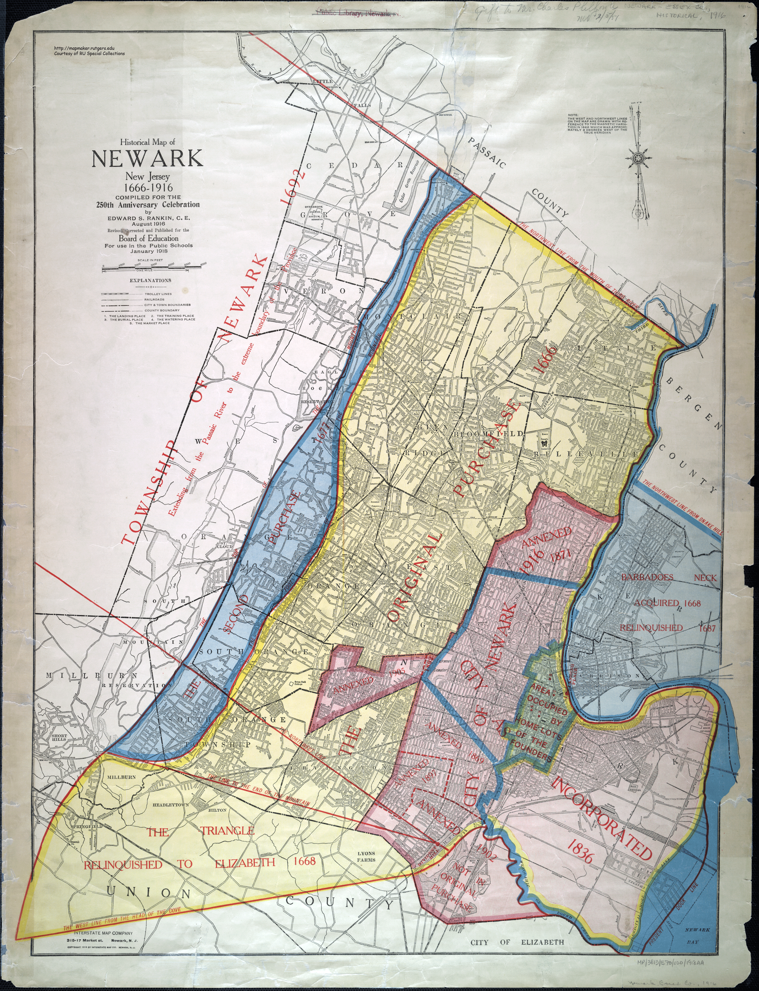
Historical Map of Newark, New Jersey, 1666-1916
Compiled for the 250th celebration by Edward S. Rankin, C.E., August 1916, revised January 1918.
Shaping the City
- The Story of New Jersey's Civil Boundaries 1606-1968
- John P. Snyder. Trenton, Bureau of Geology and Topography, 1969. Reprinted New Jersey Geological Survey, 2004.
- "The Bounds of Newark: Tract, Township and City,"
- John P. Snyder. New Jersey History 86(2), Summer 1968, 92-105.
- Newark's geographical boundaries, 1667-1967. Available?
- Indian Trails and City Streets
- Edward S. Rankin. Montclair, N.J., The Globe Press, 1927.
- Part I.: The Old Newark. Part II: Stories of Newark Streets.
- Rankin was Newark's Chief Engineer in the Division of Sewers between 1929 and 1945. In his essay on "Prehistoric Highways" [pp.75-79] Rankin proposes that Newark's earliest streets were laid out over what were originally Indian trails. Available?
- Running Brooks and Other Sketches of Early Newark.
- Edward S. Rankin. Somerville, N.J., Unionist-Gazette, 1930. Available?
- "Notes on Newark's Urban History,"
- Jacques Gubler. Architecture et comportement/Architecture & Behaviour 4(2), 1988, 157-174.
- "The originality of Newark's city plan lies in the way which the colonial settlement has been superimposed upon the Indian land pattern." Expands on the theory of Edward Rankin.
Subject Guide

Natalie Borisovets
Contact:
185 University Avenue
John Cotton Dana Library
Newark, N.J. 07102
John Cotton Dana Library
Newark, N.J. 07102
Subjects: American Studies, Communication, Criminal Justice, History - Global & Eurasian, History - North America, Journalism & Media Studies, Latin American & Caribbean Studies, Literatures in English, New Jerseyana, Political Science, Social Work, Spanish & Portuguese Studies, Women's & Gender Studies