The Newark Experience
Later Nineteenth/Early Twentieth Centuries
- Newark, N.J., 1870-1910: Chapters in the Evolution of an American Metropolis.
- Samuel H. Popper. Thesis (Ph.D.), New York University, 1952. Available?
- Report and Catalogue of the First Exhibition of Newark Industries.
- Newark, N.J., Holbrook's Steam Printing, 1872. Available?
- "Measuring Ethnic Clustering and Exposure with the Q Statistic: An Exploratory Analysis of Irish, Germans, and Yankees in 1880 Newark"
- Antonio Paez et al. Annals of the Association of American Geographers 102(1), January 2012, 84-102. Rutgers-restricted Access
- Newark: The Nation's Unhealthiest City, 1832-1895.
- Stuart Galishoff. New Brunswick, N.J., Rutgers University Press, 1988.
- Public health policy and reform, including the development of a public water supply and sewerage, in 19th century Newark. Available?
- Safeguarding the Public Health: Newark, 1895-1918.
- Stuart Galishoff. Westport, Conn., Greenwood Press, 1975.
- Focuses on the Newark Board of Health and the attempt to control contagious diseases. Available?
- Newark's Last Fifteen Years, 1904-1919: Interesting Facts, Arranged Alphabetically by Subjects.
- Newark, N.J., Newark Public Library, 1919.
- The City of Newark in Nineteen Hundred and Six.
- Speech Dlivered by Hon. Henry M. Doremus, Mayor, at Opening of New City Hall December 20, 1906. Newark, L.J. Hardhom Printing Company, [1906?].
- Newark: The City of Industry. Facts and Figures Concerning the Metropolis of New Jersey
- Newark Board of Trade. 1912.
- Reflections on the Life of Negroes in Newark, 1910-1916
- William Ashby. An address delivered to the Frontiers Club, February 16, 1972.
- Report on the Social Evil Conditions of Newark, New Jersey, to the People of Newark.
- Newark (N.J.). Citizens' Committee. Newark, N.J., 1914.
- Investigation conducted by the American Vigilance Association during August and December 1913 and January 1914. The American Vigilance Association (later incorporated into the American Social Hygiene Association) worked to 'suppress and prevent commercialized vice, and to promote the highest standard of public and private morals.' Pages 152-170: "Summary and Tables Relative to Professional Prostitutes" in Newark. Available?
- "Newark's 250th Anniversary Celebration,"
- Joseph F. Folsom. Proceedings of the New Jersey Historical Society. New Series Vol. 1, No. 3, 1916. pp. 113-128; "Additions and Corrections," p. 220.
- The Newark Posters Catalogue: Newark, New Jersey, Celebration of 250th Anniversary, 1916.
- Newark, N.J., Committee of One Hundred. Newark, N.J., Essex Press, 1915.
- Catalogue of the traveling exhibit resulting from the poster contest held in conjunction with the 250th anniversary.
- Metropolitan Aspirations: Politics and Memory in Progressive Era Newark.
- Martin V. Minner. Thesis (Ph.D), Indiana University, 2005.
- "[F]ocuses on the 250th anniversary celebration held in Newark in 1916 and the range of media and civic events, such as a pageant, parades, poster and poetry contests, an industrial exhibition, statuary, and plans for a memorial building, that marked this civic celebration. The study argues that this massive commemorative event served primarily to promote civic identity, which in turn served a number of political ends.Available?
- "Newark,"
- IN Merchants Association of Newark, N.J. First Annual Industrial Exposition. May 20-27, 1922, pp. 6-14.
- Facts and figures on Newark in the early 1920s. Cover
- Slippery When Wet
- Laura Troiano. Thesis (M.A.), Rutgers University, 2008. Available?
- "Slippery When Wet: A Young Historian's Journey into the World of Creative Non-Fiction,"
- Laura Troiano. Rethinking History: The Journal of Theory and Practice 16(1), 2012, pp. 91-108.
- "This essay is the story of my many attempts at writing a history of Prohibition and bootlegging in Newark, NJ and how those attempts have shaped the ways I think about the relationship between creative non-fiction and historical scholarship...." Rutgers-restricted Access
- New Jersey: Life, Industries and Resources of a Great State.
- Floyd William Parsons. Newark, N.J., New Jersey State Chamber of Commerce, 1928.
- Includes many Newark references as well as photographs.
- Life on Prince Street in the 1920s and 1930s
- Nat Bodian. Reminiscence of life in the heart of the Jewish section of Newark. Part of the Old Newark Memories site.
The Sights
- Sightseeing in Newark, N.J. [Pt.1?]
- Sightseeing in Newark, N.J. [Pt.2?]
- John H. Dunnachie film. 1926-1927. From the Prelinger Archives.
What They Saw
- Part of the 1st and 7th Wards
- May 1862 photograph.
- Panoramic Views of Newark
- 1912. 2 panoramic photos.
- Broad & Market Streets
- July 1916.
- Broad Street, 900 Block
- c. 1920. 2 photos.
- "Newark Long Ago: 19th Century Photographs From the Museum's Collections," Barbara Lipton. Newark Museum Quarterly 26(4), Fall 1975, pp.1-28. William F. Cone photographs.
Maps
Historical Map of Newark, New Jersey, 1666-1916
Compiled for the 250th celebration by Edward S. Rankin, C.E., August 1916, revised January 1918.
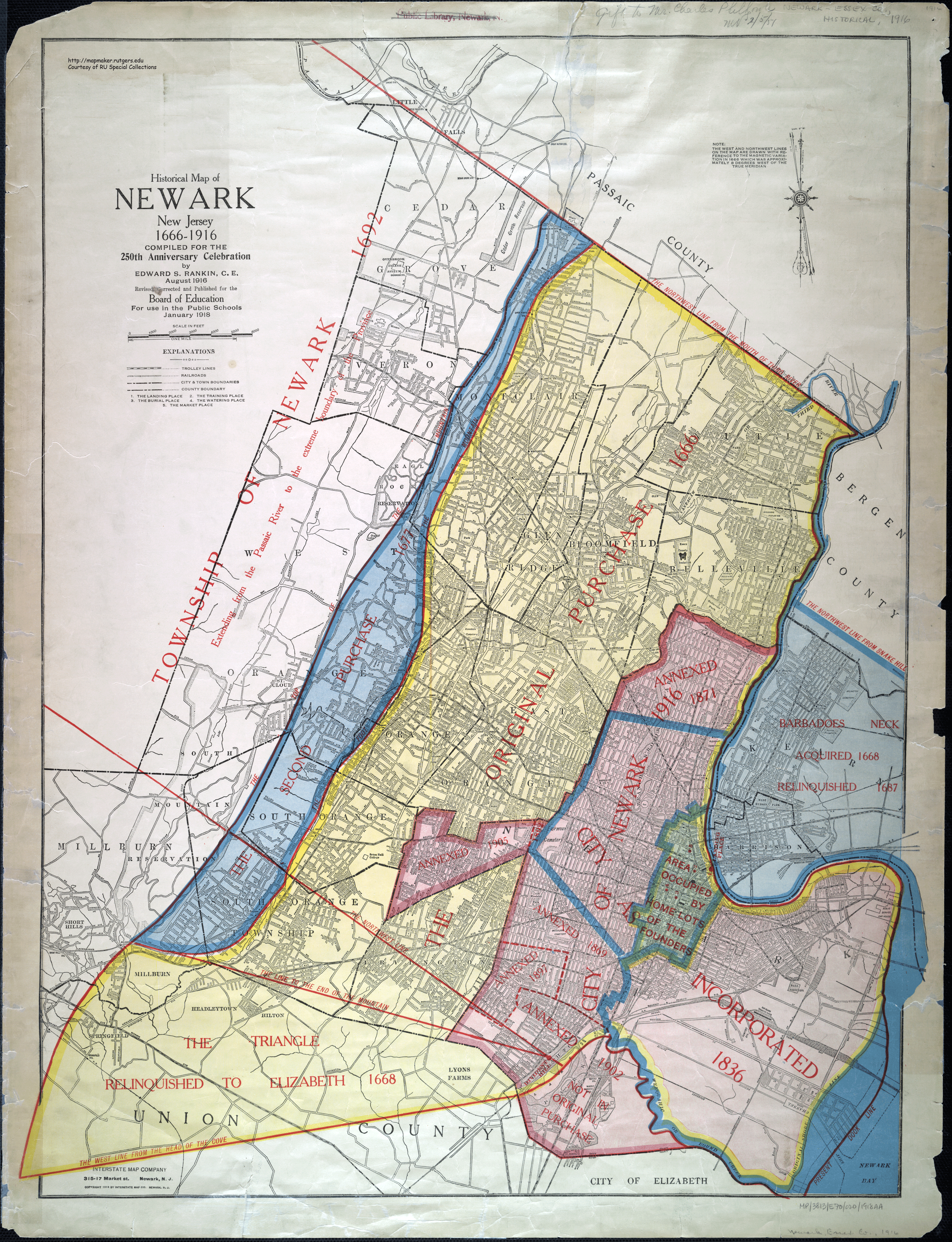
1872 Map of the City of Newark
F.W. Beers map from the 1872 State Atlas of New Jersey.
Newark, circa 1874.
From the Library of Congress Panoramic Maps series.
Newark, circa 1895.
From the Library of Congress Panoramic Maps series. See detail of the area where Rutgers-Newark
is now located.
Atlas of the City of Newark, New Jersey: From Official Records, Private Plans & Actual Surveys.
Scarlett and Scarlett. Newark, N.J., 1889.
37 detailed maps. Includes information on land owners and building materials.
Special Collections Call Number: XFOLIO G1259 .N5S33
Atlas of the City of Newark, New Jersey: From Official Records, Private Plans and Actual Surveys.
Elisha Robinson. New York, E. Robinson, 1901.
Special Collections Call Number: SNCLXF G1259 .N5R6 1901
Newark, 1904.
From the Old Newark site.
Robinson's Atlas of the City of Newark, New Jersey. Compiled From Official Records, Private Plans and Actual Surveys. Elisha Robinson. Newark, N.J., E. Robinson, 1926-1927. 3 vols.
Vol 1: Embracing the section
of the City North from Penn. R.R. Market Street and South Orange Avenue
to 12th Street to Central Avenue; Vol. 2: Embracing the
Section of the City South to Market Street and South Orange Avenue, the
Vailsburg Section and West to Broad Street., Poinier Street and
Elizabeth Avenue to City Line; Vol. 3: Embracing the Section of the City South and East
from Penna. R.R. and Market Street to Broad Street, to Poinier Street, to Elizabeth Avenue thence to City Line.
Detailed maps show buildings, dwellings and businesses, and indicate
building materials, ward lines, water pipes, sewers, and paved or
unimproved streets.
Dana Call Number: NEWARK G1259 .N5R63 1926
The "Real" History

- A Real History of Newark and Notable Newarkers Tom Fleming. Newark, N.J., Tom Fleming Cartoon Syndicate, 1916.
Humorous history with caricatures of Newark notables.
The Ironbound
-
The Ironbound District"A Study of a District in Newark, N.J., Made by Willard D. Price for the Neighborhood House." 1912?
- Newark Neighborhood House
- One page report, circa 1903. The Neighborhood House was opened by the Newark Social Settlement Association in 1905. "The 'Ironbound District' has been chosen for the first settlement partly because of its cosmopolitan nature and partly because it is the heart of the great factory district."
Newark's Children at Work
- Enforcing the Newsboy Law in New York and Newark J. K. Paulding. Charities 14, April-September, 1905, pp. 836-837.
- Child Labor in New Jersey: Part 3: The Working Children of Newark and Paterson.
- Nettie McGill. Washington, DC, Children's Bureau, 1931
- One of a series of studies of child welfare in New Jersey by the Children's Bureau in 1925. According to the 1920 census, 25 percent of Newark's 14 and 15 year-olds were in the work force. Looks at data relating to termination of school life, occupations, wages, unemployment and steadiness at work.
- Newsboys Lewis Wickes Hine's photographs of Newark newsboys, taken between 1909 and 1924.
- Shoeshine Boys and Others More Hine photos. 1912-1924.
Women's Suffrage
-
Women's Suffrage Map of NewarkGeorge Robb, 2020.
Tough Times
- Newark Women Plod in Snow to Plea for Food "Women walking through snow and slush in Newark, New Jersey, to the city hall to place before Mayor Raymond a resolution calling for purchase and sale by the city of needed food." Thomas L. Raymond was Mayor of Newark from 1915-1917 and again between 1925 and 1928.
Subject Guide

John Cotton Dana Library
Newark, N.J. 07102